Tropical Storm Chantal officially developed off the southeast coast early Saturday morning, becoming the third named system in the 2025 Atlantic hurricane season. According to the National Hurricane Center (NHC), Tropical Storm Chantal marks the first tropical system of the season to impact the United States, raising concerns for the holiday weekend.
Although Tropical Storm Chantal is not forecast to become a major hurricane, it will bring significant weather conditions, including rainfall, rip currents, and potential coastal flooding to parts of South Carolina, North Carolina, Georgia, and Florida.
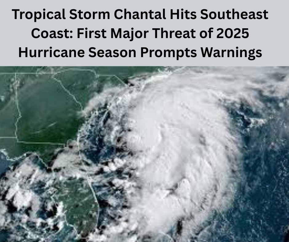
Current Location and Strength of Tropical Storm Chantal
As of Saturday morning, the center of Tropical Storm Chantal was located approximately 150 miles south-southeast of Charleston, South Carolina. The storm was moving slowly north at a speed of 2 mph, and sustained winds were recorded at 40 mph.
The NHC expects slight strengthening of the system as it continues its path toward the South Carolina coast. Forecasts suggest that it will make landfall on Sunday morning, likely between Charleston and Myrtle Beach.
Tropical Storm Chantal Prompts Warnings for Carolinas
A Tropical Storm Warning has been issued for parts of South Carolina and North Carolina, extending from South Santee River, SC, to Surf City, NC. These warnings indicate that tropical storm conditions (40+ mph winds) are expected within the next 24 hours.
Additionally, a Tropical Storm Watch is in effect from Edisto Beach to the South Santee River, signaling that tropical storm-force winds are possible in the area late Saturday night into Sunday morning.
Impacts of Tropical Storm Chantal: Rainfall, Flooding, and Surf Conditions
Heavy Rainfall Expected Across the Carolinas
The most immediate and widespread impact of it will be heavy rainfall. Meteorologists forecast 2 to 4 inches of rain in the eastern Carolinas, with some isolated locations possibly receiving up to 6 inches. The heaviest rainfall is expected to fall east of the storm’s center, potentially triggering localized flooding in low-lying areas.
Potential Storm Surge and Coastal Flooding
While Tropical Storm Chantal is not expected to cause widespread storm surge, coastal regions within the warning zones could see 1 to 3 feet of water above ground level, particularly in areas experiencing onshore winds. Coastal flooding is expected to be minor but still potentially disruptive, especially in low-lying neighborhoods.
Dangerous Rip Currents and Rough Surf
A high threat of rip currents is one of the most dangerous aspects of Tropical Storm Chantal. Beaches along the Carolinas and Georgia coast are expected to see rough surf and frequent rip currents throughout the weekend. With the July 4th holiday attracting crowds to the beaches, authorities are urging visitors to heed red flag warnings and avoid entering the water under hazardous conditions.
Short-Lived But Disruptive: How Long Will Tropical Storm Chantal Last?
Tropical Storm Chantal is expected to be a short-lived system. Meteorologists believe the storm will weaken quickly after making landfall in South Carolina on Sunday. Most of the rain and wind activity associated with Chantal should diminish by late Monday, with the Southeast region expected to dry out by Tuesday.
Weather Outlook Beyond Tropical Storm Chantal
While Tropical Storm Chantal affects the Southeast, much of the rest of the United States is experiencing calmer weather. The Northeast and Western states can expect mostly clear skies and ideal conditions for Independence Day celebrations.
However, Texas and parts of the Upper Midwest may continue to experience strong thunderstorms, damaging winds, and hail through the weekend. In fact, torrential rain in Texas earlier on Friday caused deadly flash flooding, prompting evacuations from campgrounds and low-lying homes.
Precautions and Safety Measures During Tropical Storm Chantal
Residents and visitors in areas under tropical storm warnings are advised to:
- Secure loose outdoor items that could become projectiles in gusty winds.
- Avoid flooded roads, as even a few inches of water can sweep away vehicles.
- Stay updated with the latest forecasts and emergency alerts.
- Cancel or reschedule outdoor plans and have a shelter plan in place in case of lightning or flash flooding.
- Follow beach safety advisories, especially regarding rip currents.
What Makes Tropical Storm Chantal Different?
Unlike major hurricanes that span hundreds of miles and last for days, Tropical Storm Chantal is compact and slow-moving. Despite its modest wind speeds, the storm is capable of producing intense, localized impacts, especially due to its slow forward motion, which increases rainfall totals in affected areas.
Additionally, because it is the first system of the 2025 hurricane season to impact the U.S., Tropical Storm Chantal serves as a critical reminder of the importance of storm preparedness early in the season.
Tropical Storm Chantal in the Broader Hurricane Season Context
With Tropical Storm Chantal becoming the third named storm of the Atlantic season, meteorologists are keeping a close eye on sea surface temperatures and atmospheric conditions that suggest a potentially active hurricane season. Early-season systems like Chantal often set the tone for future storm activity.
Final Thoughts: Stay Alert as Tropical Storm Chantal Approaches
As Tropical Storm Chantal makes its way toward the South Carolina coast, its effects will be felt from Florida to North Carolina, particularly in terms of heavy rainfall, rip currents, and coastal flooding. While it may not pose a severe threat compared to larger hurricanes, the storm’s timing over the holiday weekend raises concerns for travel, safety, and outdoor celebrations.
Staying informed and taking basic precautions can help minimize risks during Tropical Storm Chantal’s brief but impactful appearance on the Atlantic coast.
Read more : River North Shooting